


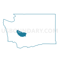
Voting District 02-058, Pierce County, Washington
About
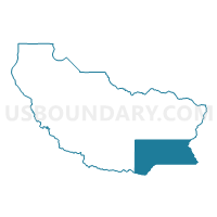
Outline

Summary
| Unique Area Identifier | 688018 |
| Name | Voting District 02-058 |
| County | Pierce County |
| State | Washington |
| Area (square miles) | 194.92 |
| Land Area (square miles) | 192.64 |
| Water Area (square miles) | 2.28 |
| % of Land Area | 98.83 |
| % of Water Area | 1.17 |
| Latitude of the Internal Point | 46.84207380 |
| Longtitude of the Internal Point | -121.73937800 |
Maps

Graphs
Select a template below for downloading or customizing gragh for Voting District 02-058, Pierce County, Washington


Neighbors
Neighoring Voting District (by Name) Neighboring Voting District on the Map
- Voting District 02-051, Pierce County, WA
- Voting District 02-055, Pierce County, WA
- Voting District 02-057, Pierce County, WA
- Voting District 31-671, Pierce County, WA
- Big Bottom Voting District, Lewis County, WA
- Cliffdell Voting District, Yakima County, WA
- Mineral Voting District, Lewis County, WA
- Nile Voting District, Yakima County, WA
Top 10 Neighboring County Subdivision (by Population) Neighboring County Subdivision on the Map
- Northwest Yakima CCD, Yakima County, WA (8,252)
- Eatonville CCD, Pierce County, WA (6,220)
- Mineral CCD, Lewis County, WA (4,175)
- Mount Rainier CCD, Pierce County, WA (3,406)
- Big Bottom CCD, Lewis County, WA (2,911)
Top 10 Neighboring Unified School District (by Population) Neighboring Unified School District on the Map
- White River School District, WA (22,116)
- Eatonville School District, WA (12,084)
- Naches Valley School District, WA (8,078)
- White Pass School District, WA (4,080)
- Morton School District, WA (2,742)
- Carbonado School District, WA (856)
Top 10 Neighboring State Legislative District Lower Chamber (by Population) Neighboring State Legislative District Lower Chamber on the Map
- State House District 2, WA (163,707)
- State House District 20, WA (141,029)
- State House District 31, WA (137,685)
- State House District 14, WA (130,478)
Top 10 Neighboring State Legislative District Upper Chamber (by Population) Neighboring State Legislative District Upper Chamber on the Map
- State Senate District 2, WA (163,707)
- State Senate District 20, WA (141,029)
- State Senate District 31, WA (137,685)
- State Senate District 14, WA (130,478)
Top 10 Neighboring 111th Congressional District (by Population) Neighboring 111th Congressional District on the Map
- Congressional District 8, WA (810,754)
- Congressional District 3, WA (779,348)
- Congressional District 4, WA (774,409)
Top 10 Neighboring Census Tract (by Population) Neighboring Census Tract on the Map
- Census Tract 732, Pierce County, WA (6,220)
- Census Tract 30.01, Yakima County, WA (4,584)
- Census Tract 9718, Lewis County, WA (4,175)
- Census Tract 701, Pierce County, WA (3,406)
- Census Tract 9720, Lewis County, WA (2,911)
Top 10 Neighboring 5-Digit ZIP Code Tabulation Area (by Population) Neighboring 5-Digit ZIP Code Tabulation Area on the Map
- 98328, WA (10,433)
- 98937, WA (4,112)
- 98361, WA (1,158)
- 98304, WA (759)
- 98323, WA (702)
- 98355, WA (628)